
Sensitivity Analysis of Deep-Learning Perception Models to Sensing Parameters (Sielemann, Bitzer et al., 2026)
subdatasets
classes
images per dataset
total images
In the study of deep learning-based models and deep neural networks (DNN), measuring their sensitivity or robustness against perturbations has been a key focus. This is especially relevant for safety-critical applications, such as fully-automated vehicles on public roads, which need to demonstrate-besides robustness against intentional adversarial manipulations-the robustness under all conditions of their operational design domain (ODD). In this context, the specific understanding of how deep learning models are affected by ODD aspects is crucial to assure safe and reliable operation.
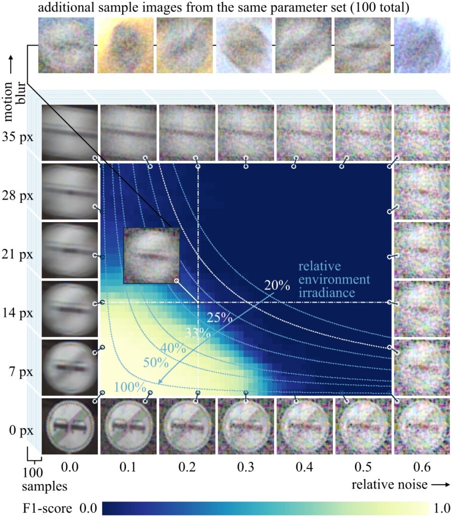
We present an approach to systematically evaluate the sensitivity of DNNs to variations in environmental conditions through the use of physically-based synthetic data, demonstrated on the task of traffic sign recognition. For this task, we leverage the data synthesis pipeline from our previous work on the Synset Signset Germany dataset, for which the comparability to real-world data was demonstrated. This pipeline is used to create a large-scale systematic dataset of perturbations with physical, exposure-related meaning, including 2,196 subdatasets, accumulating to 9,442,800 test images. This dataset is provided as open data to serve as a basis for further in-depth investigations into the performance of DNNs under challenging conditions.
The application of our testing approach indicates that the performance of DNNs can be related to the physical parameters of input image data and that the sensitivity to these parameters can be measured to a significant and reproducible degree; however, the results show high variation and complexity in the behavior of the evaluated DNNs that extend beyond simple data quality models.
Synset Signset Sensitivity Analysis Datasets
| Field | Task | License | Samples | Key Annotations | Institutions |
|---|---|---|---|---|---|
| Computer Vision | traffic sign recognition |  Creative Commons Attribution 4.0 | 4,300 independent images per subdataset, 9,442,800 images in total | Per frame: Class (sign type), environment conditions (e.g., time of day, contrast), imaging artifacts (noise, motion blur, chromatic aberration), semantic segmentation, binary mask. | Fraunhofer IOSB, KIT-IES |
Included traffic sign classes (expand)
The Synset Signset Sensitivity Analysis datasets comprise the same classes as the well-known “German Traffic Sign Recognition Benchmark“ (GTSRB)1 dataset. The class IDs directly match the traffic sign class IDs of GTSRB.
1 J. Stallkamp, M. Schlipsing, J. Salmen, and C. Igel, “The German traffic sign recognition benchmark: a multi-class classification competition,”
in The 2011 international joint conference on neural networks. IEEE, 2011, pp. 1453–1460.
| ID | Name | Image |
|---|---|---|
| 0 | Zulässige Höchstgeschwindigkeit 20 |  |
| 1 | Zulässige Höchstgeschwindigkeit 30 |  |
| 2 | Zulässige Höchstgeschwindigkeit 50 |  |
| 3 | Zulässige Höchstgeschwindigkeit 60 |  |
| 4 | Zulässige Höchstgeschwindigkeit 70 |  |
| 5 | Zulässige Höchstgeschwindigkeit 80 |  |
| 6 | Ende der zulässigen Höchstgeschwindigkeit 80 |  |
| 7 | Zulässige Höchstgeschwindigkeit 100 |  |
| 8 | Zulässige Höchstgeschwindigkeit 120 |  |
| 9 | Überholverbot für Kraftfahrzeuge aller Art |  |
| 10 | Überholverbot für Kraftfahrzeuge über 3,5 t |  |
| 11 | Vorfahrt |  |
| 12 | Vorfahrtstraße |  |
| 13 | Vorfahrt gewähren |  |
| 14 | Halt. Vorfahrt gewähren |  |
| ID | Name | Image |
|---|---|---|
| 15 | Verbot für Fahrzeuge aller Art |  |
| 16 | Verbot für Kraftfahrzeuge über 3,5 t |  |
| 17 | Verbot der Einfahrt |  |
| 18 | Gefahrenstelle |  |
| 19 | Kurve – links |  |
| 20 | Kurve – rechts |  |
| 21 | Doppelkurve – zunächst links |  |
| 22 | Unebene Fahrbahn |  |
| 23 | Schleuder- oder Rutschgefahr |  |
| 24 | Einseitig verengte Fahrbahn – Verengung rechts |  |
| 25 | Arbeitsstelle |  |
| 26 | Lichtzeichenanlage |  |
| 27 | Fußgänger – Aufstellung rechts |  |
| 28 | Kinder – Aufstellung rechts |  |
| 29 | Radverkehr – Aufstellung rechts |  |
| ID | Name | Image |
|---|---|---|
| 30 | Schnee- oder Eisglätte |  |
| 31 | Wildwechsel – Aufstellung rechts |  |
| 32 | Ende sämtlicher streckenbezogener Geschwindigkeitsbeschränkungen und Überholverbote |  |
| 33 | Vorgeschriebene Fahrtrichtung – rechts |  |
| 34 | Vorgeschriebene Fahrtrichtung – links |  |
| 35 | Vorgeschriebene Fahrtrichtung – geradeaus |  |
| 36 | Vorgeschriebene Fahrtrichtung – geradeaus oder rechts |  |
| 37 | Vorgeschriebene Fahrtrichtung – geradeaus oder links |  |
| 38 | Vorgeschriebene Vorbeifahrt – rechts vorbei |  |
| 39 | Vorgeschriebene Vorbeifahrt – links vorbei |  |
| 40 | Kreisverkehr |  |
| 41 | Ende des Überholverbotes für Kraftfahrzeuge aller Art |  |
| 42 | Ende des Überholverbotes für Kraftfahrzeuge über 3,5 t |  |
Environment selection (expand)
All HDRIs used by the rendering pipeline for lighting and background modulation stem from Polyhaven1. In total, 523 environment maps were used, their names are given in the following tabular.
| Abandoned Church | Farm Field | Mpumalanga Veld | Simon's Town Rocks |
| Abandoned Hopper Terminal 01 | Farm Sunset | Mud Road | Sisulu |
| Abandoned Hopper Terminal 02 | Felsenlabyrinth | Muddy Autumn Forest | Skate Park |
| Abandoned Hopper Terminal 03 | Fish Eagle Hill | Museum of History | Skidpan |
| Abandoned Hopper Terminal 04 | Fish Hoek Beach | Museumplein | Skukuza Golf |
| Abandoned Parking | Flower Hillside | Nagoya Wall Path | Small Harbor 01 |
| Abandoned Pathway | Flower Road | Narrow Moonlit Road | Small Harbor 02 |
| Abandoned Slipway | Forest Cave | Nature Reserve Forest | Small Harbour Morning |
| Abandoned Tank Farm 01 | Forest Grove | Near The River 01 | Small Harbour Sunset |
| Abandoned Tank Farm 02 | Forest Slope | Near The River 02 | Small Rural Road |
| Abandoned Tank Farm 03 | Forgotten Miniland | Netball Court | Small Rural Road 02 |
| Abandoned Tank Farm 04 | Fouriesburg Mountain Cloudy | Neuer Zollhof | Snow Field |
| Abandoned Tank Farm 05 | Fouriesburg Mountain Lookout | Neurathen Rock Castle | Snow Field 2 |
| Abandoned Waterworks | Fouriesburg Mountain Lookout 2 | Niederwihl Forest | Snowy Cemetery |
| Ahornsteig | Fouriesburg Mountain Midday | Night Bridge | Snowy Field |
| Air Museum Playground | Freight Station | Ninomaru Teien | Snowy Forest |
| Aloe Farm Shade House | Frozen Lake | Nkuhlu | Snowy Forest Path 01 |
| Alps Field | Furry Clouds | Noga | Snowy Forest Path 02 |
| Altanka | Future Parking | Noon Grass | Snowy Hillside |
| Amphitheatre Zanzibar Fort | Gamrig | Northcliff | Snowy Hillside 02 |
| Approaching Storm | Garden Nook | Oberer Kuhberg | Snowy Park 01 |
| Arboretum | Geislingen An Der Steige | Old Outdoor Theater | Soliltude |
| Aristea Wreck | Glencairn Expressway | Old Quarry Gerlingen | Solitude Night |
| Autumn Crossing | Goegap | Old Tree in City Park | Spaichingen Hill |
| Autumn Field | Goegap Road | Orbita | Spiaggia di Mondello |
| Autumn Forest 01 | Golden Bay | Orlando Stadium | Spree Bank |
| Autumn Forest 02 | Golf Course Sunrise | Ostrich Road | Spruit Dawn |
| Autumn Forest 03 | Gothic Manor 01 | Ouchy Pier | Spruit Sunrise |
| Autumn Forest 04 | Gothic Manor 02 | Outdoor Umbrellas | St. Peters Square Night |
| Autumn Ground | Graveyard Pathways | Outdoor Workshop | Stadium 01 |
| Autumn Hockey | Gray Pier | Overcast Soil | Steinbach Field |
| Autumn Meadow | Green Point Park | Overcast Soil 2 | Sterkspruit Falls |
| Autumn Park | Green Sanctuary | Ox Bridge Morning | Stone Alley |
| Autumn Road | Greenwich Park | Palermo Park | Stone Alley 02 |
| Aviation Museum | Greenwich Park 02 | Palermo Sidewalk | Stone Alley 03 |
| Aviation Museum Hill | Greenwich Park 03 | Palermo Square | Stone Pines |
| Balcony | Gum Trees | Parched Canal | Straw Rolls Field 01 |
| Beach Cloudy Bridge | Hamburg Canal | Park Bench | Stream |
| Beach Parking | Hanger Exterior Cloudy | Park Parking | Street Lamp |
| Belfast Farmhouse | Hansaplatz | Partial Eclipse | Studio Garden |
| Belfast Open Field | Harties | Pedestrian Overpass | Stuttgart Hillside |
| Belfast Sunset | Harvest | Petit Port | Stuttgart Suburbs |
| Bell Park Dawn | Herkulessäulen | Pfälzer Forest 01 | Suburban Field 01 |
| Bell Park Pier | Hilltop Construction | Piazza Bologni | Suburban Field 02 |
| Belvedere | Hilly Terrain 01 | Piazza Martin Lutero | Suburban Parking Area |
| Bergen | Hochsal Field | Piazza San Marco | Summer Stage 01 |
| Bethnal Green Entrance | Hochsal Forest | Pink Sunrise | Summer Stage 02 |
| Between Bridges | Hotel Rooftop Balcony | Pizzo Pernice | Sunflowers |
| Binnenalster | Illovo Beach Balcony | Pond | Sunny Vondelpark |
| Birchwood | Immenstädter Horn | Pond Bridge Night | Sunset Fairway |
| Bismarckturm | Industrial Sunset | Pool | Sunset Forest |
| Bismarckturm Hillside | Industrial Sunset 02 | Portland Landing pad | Sunset in the Chalk Quarry |
| Blau River | J&E Gray 02 | Potsdamer Platz | Syferfontein 0d Clear |
| Blaubeuren Church Square | J&E Gray Park | Preller Drive | Syferfontein 1d Clear |
| Blaubeuren Hillside | Joburg Central Sunset | Pretville Street | Syferfontein 6d Clear |
| Blaubeuren Night | Kiara 1 Dawn | Promenade De Vidy | Syferfontein 18d Clear |
| Blaubeuren Outskirts | Kiara 2 Sunrise | Pump Station | Symmetrical Garden |
| Blouberg Sunrise 1 | Kiara 3 Morning | Pylons | Symmetrical Garden 02 |
| Blouberg Sunrise 2 | Kiara 4 Mid-Morning | Quarry 01 | Table Mountain 1 |
| Blue Grotto | Kiara 5 Noon | Quarry 02 | Table Mountain 2 |
| Blue Lagoon | Kiara 6 Afternoon | Quarry 03 | Tears of Steel Bridge |
| Blue Lagoon Night | Kiara 7 Late-Afternoon | Quarry 04 | Teatro Massimo |
| Borghese Gardens | Kiara 8 Sunset | Quarry Cloudy | Teufelsberg Ground 1 |
| Brick Factory 01 | Kiara 9 Dusk | Quattro Canti | Teufelsberg Ground 2 |
| Brick Factory 02 | Killesberg Park | Qwantani | Teufelsberg Roof |
| Buikslotermeerplein | Klippad Dawn 1 | Qwantani Dawn | The Lost City |
| Cambridge | Klippad Dawn 2 | Qwantani Dusk 1 | The Sky Is On Fire |
| Canary Wharf | Klippad Sunrise 1 | Qwantani Dusk 2 | Tiber 1 |
| Cannon | Klippad Sunrise 2 | Qwantani Patio | Tiber 2 |
| Cape Hill | Kloetzle Blei | Qwantani Sunrise | Tiber Island |
| Castel St. Angelo Roof | Kloofendal 28d Misty | Qwantani Sunset | Tief Etz |
| Cayley Lookout | Kloofendal 38d Partly Cloudy | Railway Bridge 02 | Tiergarten |
| Cedar Bridge | Kloofendal 43d Clear | Railway Bridges | Tucker Wreck |
| Champagne Castle 1 | Kloofendal 48d Partly Cloudy | Rainforest Trail | Turning Area |
| Chapman's Drive | Kloofendal Misty Morning | Rathaus | Ulmer Muenster |
| Chinese Garden | Kloofendal Overcast | Red Hill Cloudy | Umhlanga Sunrise |
| Circus Maximus 1 | Kloppenheim 01 | Red Hill Curve | Under Bridge |
| Circus Maximus 2 | Kloppenheim 02 | Red Hill Straight | Urban Alley 01 |
| Citrus Orchard | Kloppenheim 03 | Red Wall | Urban Courtyard |
| Citrus Orchard Road | Kloppenheim 04 | Reichstag 1 | Urban Courtyard 02 |
| Clarens Midday | Kloppenheim 05 | Reinforced Concrete 02 | Urban Street 01 |
| Clarens Night 01 | Kloppenheim 06 | Residential Garden | Urban Street 02 |
| Clarens Night 02 | Kloppenheim 07 | Resting Place | Urban Street 03 |
| Cliffside | Konigsallee | Resting Place 2 | Urban Street 04 |
| Cloud Layers | Konzerthaus | Rhodes Memorial | Vatican Road |
| Cloudy Cliffside Road | Lago d'Isola | River Rocks | Veld Fire |
| Cloudy Vondelpark | Lake Pier | River Walk 1 | Venetian Crossroads |
| Cobblestone Street Night | Lakes | River Walk 2 | Venice Dawn 1 |
| Colosseum | Lakeside | Rocky Ridge | Venice Dawn 2 |
| Construction Yard | Lakeside Dawn | Rogland Clear Night | Venice Sunrise |
| Countrytrax Midday | Lakeside Sunrise | Rogland Moonlit Night | Venice Sunset |
| Courtyard | Laufenurg Church | Rogland Overcast | Versveldpas |
| Courtyard Night | Lauter Waterfall | Rogland Sunset | Viale Giuseppe Garibaldi |
| Crosswalk | Learner Park | Rolling Hills | Victoria Curve 01 |
| Crystal Falls | Leibstadt | Roof Garden | Victoria Curve 02 |
| Dam Bridge | Lenong 1 | Roofless Ruins | Victoria Sunset |
| Dam Road | Lenong 2 | Rooftop Day | Vignaioli |
| Dam Wall | Lenong 3 | Rooftop Night | Vignaioli Night |
| Dark Autumn Forest | Lilienstein | Rooitou Park | Wasteland Clouds |
| Delta 2 | Limehouse | Rosendal Mountain Midmorning | Waterbuck Trail |
| Derelict Highway Midday | Limpopo Golf Course | Rosendal Park Sunset | Whipple Creek Gazebo |
| Derelict Highway Noon | Little Paris Eiffel Tower | Rosendal Plains 1 | Whipple Creek Regional Park 01 |
| Derelict Overpass | Little Paris Under Tower | Rosendal Plains 2 | Whipple Creek Regional Park 04 |
| Derelict Underpass | Lonely Road Afternoon | Rotes Rathaus | White Cliff Top |
| Dikhololo Night | Lot 01 | Round Platform | Wide Street 01 |
| Dikhololo Sunset | Lot 02 | Ruckenkreuz | Wide Street 02 |
| Dirt Bike Track 01 | Lush Dirt Path | Rural Asphalt Road | Wildflower Field |
| Drackenstein Quarry | Lythwood Field | Rural Crossroads | Winter Evening |
| Drakensberg Solitary Mountain | Lythwood Terrace | Rural Graffiti Tower | Winter Lake 01 |
| Dreifaltigkeitsberg | Mall Parking Lot | Rural Landscape | Winter Orchard |
| Dresden Moat | Meadow | Rural Winter Roadside | Winter River |
| Dresden Square | Meadow 2 | Rustig Koppie | Winter Sky |
| Driving School | Mealie Road | Sabie Tent | Wobbly Bridge |
| Dry Cracked Lake | Medieval Cafe | Safari Sunset | Wooden Motel |
| Dry Field | Missile Launch Facility 02 | San Giuseppe Bridge | Woods |
| Dry Hay Field | Missile Launch Facility 03 | Sandsloot | Xanderklinge |
| Dry Meadow | Misty Dawn | Satara Night | Xiequ Yuan |
| Dry Orchard Meadow | Misty Farm Road | Satara Night (No Lamps) | Yellow Field |
| Dusseldorf Bridge | Misty Pines | Schachen Forest | Zavelstein |
| Ehingen Hillside | Modern Buildings | Schadowplatz | Zhengyang Gate |
| Ehingen Hillside 02 | Modern Buildings 2 | Scythian Tombs | Zwartkops Curve Afternoon |
| Eilenriede Labyrinth | Modern Buildings Night | Scythian Tombs 2 | Zwartkops Curve Morning |
| Eilenriede Park | Monbachtal Riverbank | Secluded Beach | Zwartkops Curve Sunset |
| Emmarentia | Monk's forest | Shady Patch | Zwartkops Start Afternoon |
| Epping Forest 01 | Monte Scherbelino | Shanghai Bund | Zwartkops Start Morning |
| Epping Forest 02 | Montorfano | Shanghai Riverside | Zwartkops Start Sunset |
| Etzwihl | Moonless Golf | Shudu Lake | Zwartkops Straight Afternoon |
| Evening Field | Moonlit Golf | Signal Hill Dawn | Zwartkops Straight Morning |
| Evening Meadow | Mossy Forest | Signal Hill Sunrise | Zwartkops Straight Sunset |
| Evening Road 01 | Moulton Falls Train Tunnel East | Simon's Town Harbour | Zwinger Night |
| Factory Yard | Moulton Station Train Tunnel West | Simon's Town Road |
Metadata and label details (expand)
Mask images
The mask images mark all image areas showing the depicted traffic sign. They are given as binary png images containing only black and white pixels.
| Class | R | G | B | Hex | |
|---|---|---|---|---|---|
| Background | 0 | 0 | 0 | #000000 | |
| Foreground traffic sign shape | 255 | 255 | 255 | #ffffff |


OGRE3D images


Semantic label images


Mask images
Semantic label images
The label images mark the different areas of the traffic sign itself, which enables to reconstruct the clean traffic sign and furthermore the sky, the traffic sign pole, other traffic signs, and tree parts that protrude into the picture. The labels are assigned as follows:
| Class | R | G | B | Hex | |
|---|---|---|---|---|---|
| Black areas of the traffic sign | 50 | 50 | 50 | #323232 | |
| White areas of the traffic sign | 255 | 255 | 255 | #ffffff | |
| Red areas of the traffic sign | 175 | 0 | 75 | #af004b | |
| Orange areas of the traffic sign | 225 | 125 | 25 | #e17d19 | |
| Yellow areas of the traffic sign | 200 | 200 | 75 | #c8c84b | |
| Blue areas of the traffic sign | 0 | 100 | 125 | #00647d | |
| Green areas of the traffic sign | 25 | 150 | 125 | #19967d | |
| Tree | 50 | 200 | 158 | #32C89E | |
| Sky | 150 | 200 | 200 | #96c8c8 | |
| Traffic sign pole | 125 | 25 | 75 | #7d194b |
JSON files
For each image the Synset Background Effect datasets contain a json file with the corresponding metadata. The json files include:
| name | range | example | description |
|---|---|---|---|
| dataset | “Synset – Sensitivity Analysis of Deep-Learning Perception Models to Sensing Parameters” | “Synset – Sensitivity Analysis of Deep-Learning Perception Models to Sensing Parameters” | Name of dataset |
| subdataset | Naming convention: Dataset-[motion blur pixels]-[additive noise level] motion blur pixels from 0 to 35 in single pixel steps, additive noise level from 0.0 to 0.06 in 0.01 steps. | Dataset-2-0150 | Identifier of the (sub-)datasets. The dataset includes 2,196 subdatasets consisting of 36 motion blur steps x 61 additive noise steps. |
| image.baseID | [0, …, 99] | 78 | Image’s base ID. Is between 0 and 99 since each subdataset class contains 100 images. |
| image.path | relative file path | Dataset-26-0160/19/11_img.png | Relative path to the image to which the json file refers. |
| image.width | 48 | 48 | Width of the corresponding image. |
| image.height | 48 | 48 | Height of the corresponding image. |
| geometry.renderingEngine | OCTAS/OGRE3D | OCTAS/OGRE3D | For all images of these datasets the OGRE3D render engine (rasterization) was used. |
| geometry.trafficSignClass | [0, …, 42] one of the 43 traffic sign classes | 17 | Defines the depicted traffic sign’s class as id. All available IDs can be looked up in the previous section “Traffic sign selection”. |
| environment.name | See previous section “Environment selection” | Farm Field | Name of the used Polyhaven environment map. In total, 523 different environment maps where used for the dataset generation (see previous section). |
| environment.dayTime | MorningAfternoon, SunriseSunset, Midday, Night, ‘NotSpecified | Midday | Depicted time of day. |
| environment.basicLocation | Outdoor | Outdoor | Depicted basic location. |
| environment.detailedLocation | Urban, Suburban, Road, Rail, Nature, Beach, BelowBridge, Greenhouse, Special | Suburban | Depicted detailed location. |
| environment.weather | Clear, Overcast, PartlyCloudy, NotSpecified | PartlyCloudy | Basic weather information. |
| environment.contrast | LowContrast, MediumContrast, HighContrast, NotSpecified | HighContrast | Specified environment contrast. |
| environment.light | Natural, Artificial, NotSpecified | Natural | Depicted light type. Indoor and night environments are typicalle illuminated by artificial light. |
| environment.season | Autumn, Winter, Summer, NotSpecified | Summer | Depicted season. Unfortunately, this information is not available for some of the environment maps. |
| imageEffects.chromaticAberration.angle | 0.0 | 0.0 | Used angle for chromatic aberration given in radian. |
| imageEffects.chromaticAberration.pixels | 0.0 | 0.0 | Applied width of chromatic aberration in pixel. |
| imageEffects.motionBlur.angle | [0.0, 2·pi) | 4.20759929278776 | Used angle for motion blur given in radian. |
| imageEffects.motionBlur.pixels | [0, 35] | 24 | Applied width of motion blur in pixel. |
| imageEffects.globalBlurStdDev | 0.4 | 0.4 | Gaussian kernel standard deviation of overall blur added to image. |
| imageEffects.relativeNoiseLevel | 0.0 | 0.0 | Scales the relative noise. |
| imageEffects.additiveNoiseLevel | [0.0, 0.6] | 0.4 | Scales the additive noise. |
| imageEffects.aecError | 0.0 | 0.0 | Automatic exposure correction error. |
| imageEffects.whitePointAccuracy | 1.0 | 1.0 | Accuracy of the white balance (0 = no correction, 1 = gray world). |
| imageEffects.flares | false | false | Specifies whether lense flares where simulated or not. |
| imageEffects.digitalImageSharpening.sigma | 1.5 | 1.5 | Gaussian kernel standard deviation applied to receive the blured image for unsharp masking. |
| imageEffects.digitalImageSharpening.strength | 0.4 | 0.4 | Amount of unsharp masking. |
| imageEffects.digitalImageSharpening.threshold | 0.02 | 0.02 | Threshold from which difference between image and blur image the image is digitally sharpened. |
| imageEffects.bayerPattern | true | true | Specifies whether bayer pattern artifacts where simulated or not. |
Paper and reference
This work is licensed under Creative Commons Attribution 4.0. 

To cite this work in your scientific publication, please use the following bibliography entry:
Sielemann, A., Bitzer, N., Roschani, M., Ziehn, J., and Beyerer, J. (2026). Sensitivity Analysis of Deep-Learning Perception Models to Sensing Parameters. In 2026 IEEE 29th International Conference on Intelligent Transportation Systems (ITSC).
@inproceedings{sensitivity_analysis_sielemann_2026,
  title={{Sensitivity Analysis of Deep-Learning Perception Models to Sensing Parameters}},
  author={Sielemann, Anne and Bitzer, Niklas and Roschani, Masoud and Ziehn, Jens and Beyerer, Juergen},
  booktitle={2026 IEEE 29th International Conference on Intelligent Transportation Systems (ITSC)},
  year={2026}
}
In case of copying and redistributing, or publishing an adapted version of our datasets, please provide the name of our dataset, the creator names, a copyright notice, a link to this website, a license notice with link to the license, and, if changes were made, a disclaimer notice, and a short description of the applied changes. For example, as follows:
This work is based on Sensitivity Analysis of Deep-Learning Perception Models to Sensing Parameters
by Anne Sielemann, Niklas Bitzer, Masoud Roschani, Jens Ziehn, and Juergen Beyerer,
© 2026 Fraunhofer IOSB, All rights reserved.
Link: https://synset.de/datasets/synset-signset-ger/sensitivity-analysis/
Licence: CC BY 4.0
Disclaimer: The original authors are neither affiliated nor responsible for any applied changes.
External platforms
Dataset (Hugging Face)
Credits
This work was funded in part by the German Federal Ministry for Economic Affairs and Energy (BMWE) within the program “New Vehicle and System Technologies” as part of the AVEAS research project, and conducted within the scope of the KAMO: Karlsruhe Mobility High Performance Center.